Whitfield Cross. An odd name for a road that doesn’t have a cross on it.
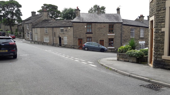
Leading from Gladstone Street up to Hague Street/Cliffe Road, the road takes you past Whitfield Wells, and into the heart of the Whitfield Conservation Area. I lived on King Street for a number of years, and regularly walked up and down the street, without really noticing the name beyond “hmmm, I bet there was cross here at some stage”.
However, whilst delving into the history of the area, I came across an article by the marvellous Robert Hamnett (my namesake) entitled “Botanical Ramble to Moorfield”, dated to about 1890. There is not much botany, but it is a goldmine of local history. You can read the article in PDF form here via the scanned scrapbooks of the New Mills History Society – they have a whole bunch of them to ready to read, all from the late 19th and early 20th century, and all history local to New Mills and surrounding areas, including Glossop. But I digress…
As I read the article my jaw dropped. I repeat the relevant chapter here in full as it is full of great language, some of which might need explaining.
“In the latter part of the last century the Cross Cliffe lads planned and partially carried out what was to them a most daring and audacious deed. One ” Mischief Night,” the eve of the first of May, it was resolved to steal the Whitfield cross. In the depth of night, when all was quiet, and the Whitfield lads were slumbering or dreaming of their “May birch”, the Cross Cliffe invaders came and detached a portion of the cross. With secrecy, care, and much labour, it was conveyed away nearly to its projected destination, but the exertions required for the nefarious deed had been under estimated, their previous work in removing all articles left carelessly in the yards or at the back doors of the good people of Cross Cliffe and neighbourhood, such as clothes lines, props, buckets, etc., etc., to their “May birch” had already taken much of their energy out of them, and, coupled with the steepness of the ascent to the “Top o’ th’ Cross,” distance and roughness of the road to Cross Cliffe, and the weight of the stone, they were reluctantly obliged to abandon their “loot” in the last field near to the pre-arranged destination. What the feelings were of the Whitfield lads on discovering the desecration and loss of a portion of their cross can be better imagined than described. The stolen portion remained in the field for some years. Mr Joseph Hague, of Park Hall, was solicited to restore the cross to its original form and position, but being imbued with a little Puritanism, he refused, and the other portions gradually disappeared until there is nothing left of the Whitfield Cross, except the stolen portion, which is now part and parcel of a stile in a field at Cross Cliffe, where the then tenant of the field placed it, over a century ago.”
“Blimey!”, thought I!
Date wise, the removal of the cross would have been 1790 or so. I find it interesting that the boys of Crosse Cliffe carried half a metric ton of stone for a prank… no wonder they left it a short distance from where it originally stood. An interesting bit of trivia here, though; in the northern counties of Yorkshire, Lancashire, Derbyshire, and Cheshire, Mischief Night was on May Eve rather than November 4th as it is now. How and why it switched, no one knows, but I can remember my father telling me about it (born in 1942 in Macclesfield), as well as my grandfather (born in 1909 in Blackley). A little research on the internet repays a lot of information about this, though curiously not the origin of the phrase “May birch”, meaning a prank, which I can find no reference to anywhere else.
So there the cross sits still, passed each day by dozens of dog walkers and hikers.
Upon reading this passage I quite literally ran out and had a look around, but, not knowing exactly where it was (and it is not marked on any OS Map that I have seen), I drew a blank. Weeks later, walking for pleasure rather than exploring, I walked along the right path, and the cross hoved into view.
And it really is unmistakable.
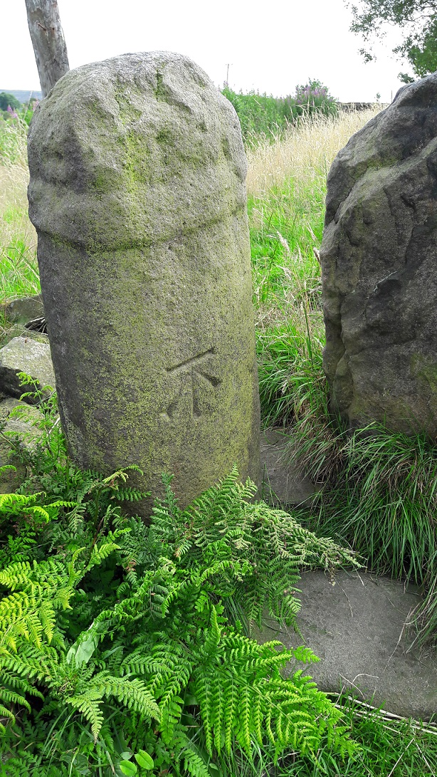
Technically, it is a 9th Century Mercian Round Shaft. That is, it is Anglo-Saxon in origin, carved and placed sometime between 800 and 900AD, and is of a type that is only found in this relatively small geographical area, the kingdon of Mercia. I say ‘this’ area, but technically we are living in the land of the Pecsaetan – the peak dewllers – an independent tribe until they merged with the Mercians prior to the invasion of 1066. Crosses normally have square or rectangular shafts, but the Round Shaft are characterised by an almost pot-bellied round shape, and the very characteristic band around the neck below the cross itself. Sometimes the shafts are decorated, but more often they are plain, as is our cross. Originally, it would have had a simple cross form on the top, just above the collar, and this as well as the neck, could sometimes decorated in panels. There are a few other examples of the round shaft in the area, but the closest are Robin Hood’s Picking Rods (which will be the subject of a future post).
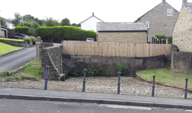
Hamnett suggests that the original location for our cross was at the Whitfield Wells, and the early maps show an area set back from the road that would work. However, it would make more sense for the cross to have stood at the top of Whitfield Cross (the road) as crosses of this sort usually mark road junctions. Here, there is the meeting of three (then) important roads.
The old pack horse route comes from the south (Peak Forest, Buxton, and Chesterfield) through Gnat Hole, along Hague Street, through to the appropriately named Cross Cliffe, down to Old Glossop (for local traffic – the market and the parish church on Sundays), and on to Woodhead (and Yorkshire beyond, for commercial traffic). The stone would have marked the junction of the track that went along Whitfield Cross, Freetown, Hollincross Lane (Holy Cross? A cross standing by, or covered in, Holly?), Slatelands, and onto Simmondley and beyond. There was another spur coming out along what is now Gladstone Street, leading to that area of the town, and again onto Woodhead.
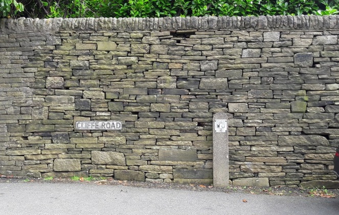
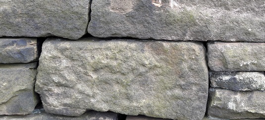
As we can see in the top photograph, the height of the land on either side of Whitfield Cross (the road) is surely testament to the age of the trackway, it being worn down to its present depth by millennia of use.
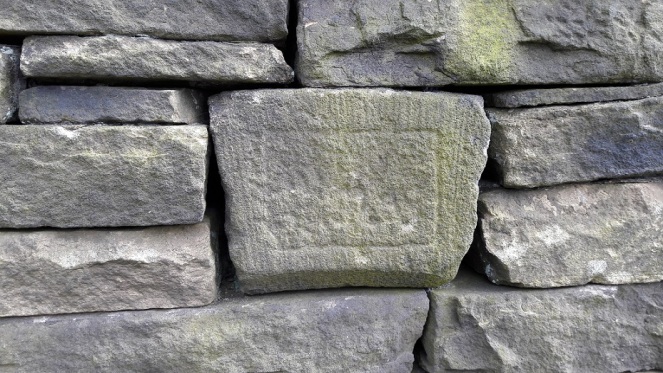
Neville Sharpe in his masterful study Stone Crosses of the Peak District notes that there are several large pieces of large built into the wall at the junction that could have formed the cross base. Closer inspection reveals numerous stones that have been re-used in the wall, several of which could be related to the cross, but without dismantling it in search of sockets, we can’t be certain.
According to Sharpe, John Nelson, an assistant to John Wesley, preached at the cross in the mid 1700’s. This is very typical of the Wesleyan way – preaching outside and using a local landmark – and I’m surprised that Wesley himself didn’t preach here, given his activities in and love for the area. Alas, there is no mention of this is his diaries. There is a very interesting piece about the history of Methodism in the area, including a biography of Nelson, here.
I wonder how many of those dog walkers and hikers are aware of what it is they are passing by when they use that stile? Seriously though, I urge you to go and see it – it is truly a remarkable piece of history, and one that deserves a better fate than is currently befalling it.
I have a big idea about the cross! I would love to see it restored to its original site, or better yet, outside the Whitfield Wells, with a little placard explaining the history of both. The setting is perfect, and it would surely be a fantastic companion to the wells, particularly when dressed. Although in the infant stages, I am exploring possibilities… watch this space.

In “Glossop Remembered” page 105 Neville Sharpe notes that in a wall at the western end of Carr House Lane (SK038935) there’s what appears to be the horizontal (square) stone of a guide stoop, bearing on its visible faces (presumably either side of the wall) the words “To Glossop” and “To Dinting.” I’ve never actually seen it, but if that presumption’s correct, I’m at a loss to know where it originally stood. Sharpe assumed Whitfield Cross, but on the principle that the traveller turned to the right, i.e following an imaginary arrow, it must have been at a junction where (Old) Glossop and Dinting were in opposite directions, and that wasn’t the case at Whitfield Cross as they are at right-angles. What’s on the other faces would solve the problem, but that would mean dismantling the wall. Sharpe suggests “Sheffield” and “Chapel” but that doesn’t make sense – Glossop and Chapel were in opposite directions, and Carr House Lane isn’t, as he thought, an ancient packhorse route going east – it cuts across the old open fields and so must post-date their enclosure. Wherever, it’s likely to date from the late 17th-early 18th century and must have been at the junction of important ways in use at that time.
One of Neville’s many other services to local history was to transcribe for the Heritage Trust the whole of Robert Hamnett’s newspaper articles, which are the basis of all subsequent histories of Glossop. There’s a copy in Glossop Library, and the Trust is considering putting them on its website as part of its drive to increase online access to its archive.
I note that on the walk around Whitfield Hamnett pointed out Lees Hall across the valley in Simmondley, observing that “It is a very old place, the former hall having had evidently a moat round it. It is most desirable to obtain more information about this spot, but the present occupiers are too inaccessible to obtain it, being too old to bother with enquirers”. Hamnett clearly knew enough to know that the site was important, and had obviously made attempts to find out more and been rebuffed, and what’s surprising is that subsequent historians left it at that and that it was another 110 years before a team of us from the Archaeological Society (GLAS) examined the current buildings during a major refurbishment, and put that together with information from the Heritage Trust’s Wills and Inventories database to establish that there had indeed been a large mediaeval hall on the site, probably demolished around the start of the 18th century. Whether there was a moat, though, is a question which may well have to be resolved by yet another generation.
LikeLike
Hmmmm. I have tried to find that guide stone several times, but have been unsuccessful each time. Following your comment I went back and was again unsuccessful. Autumn is clearly the wrong time with all the growth and bramble – I shall wait until January to try again. It is an interesting one, indeed. You are right in that it would be in the wrong place if Dinting and Glossop were on opposite sides, but would actually work perfectly if it stood at roughly the top of Whitfield Cross and read as the following (assuming the imaginary arrow to the right):
North Side – ‘To Dinting’ (via Freetown, Hollin Cross Lane, and Pikes Lane)
East Side – ‘To Glossop’ (via Cliffe Road, Mill Town, etc.)
South Side – ‘To Sheffield’ (via Carr House Lane, Derbyshire Level (?) and then onto the Snake Pass)
West Side – ‘To Chapel’ (via Gnat Hole, Chunal, etc.)
Sharp is not clear in what order the words are… we have assumed opposite sides, but perhaps not.
This still leaves the problem of Carr House Lane not being an ancient pack horse route. How certain are we about this? I walked it again the other day, and it certainly looks like a greenway to me. It is very deeply worn in places, so seemingly of some age, and there is a stone built water trough, spring fed, on the right just before the turn off for Whitfield Barn. The path down to Whitfield Barn is similarly deeply worn, and thus of the same age, and importantly here, at the junction of the two paths is the Carr House Stone Cross. I’m not sure it really should be described as a ‘cross’ as such, but it is certainly a waymarker, marking the junction, which surely would not have been needed for ‘local’ traffic only.
The point about the road going over the fields stands at the western end, but if you look at the fields around the road after it kinks east toward Carr House, they do indeed ‘respect’ the path – it was there prior to the enclosure.
As a working hypothesis then, perhaps those western four fields were enclosed with acreage in mind, and were laid out as though the trackway wasn’t there?
Or perhaps the western track is more modern than the eastern end, and that it orginally went straight up past Bank House and turned north to meet the track at the ‘kink’?
There is a lot more going on here than at first glance, and further research is needed!
Interesting re: Lees Hall. Moated or not, a medieval hall is particularly impressive. What evidence, if any, was left? And is there any more field work planned?
LikeLike
I very much doubt whether there was any ancient long-distance way branching north-east from Whitfield – it wouldn’t have made sense, as any travellers coming up from the south who then wanted to head east towards Sheffield (the only feasible direction) could do that at several earlier points. Any ways out of the village in that direction would therefore have been purely local, for access to the open arable fields and, until it was enclosed, to the common beyond. After it was enclosed, ways would be established to connect the outlying farms to the village. We don’t know exactly when the Whitfield open-field system was abandoned, but there’s a date for Glossop of 1580 and from what we know of the developments in the manor around that time, it’s likely to have gone out of use by the mid C17th as sheep farming became predominant. Progressive enclosure of the common would then follow, probably before the outlying farms were established on it starting in the mid-late C18th, although the outer common, mostly beyond Derbyshire Level, wasn’t enclosed till 1813.
People often assume “sunken lanes” to be an indicator of great antiquity, but I don’t think that’s true. Horse and foot traffic across open ground doesn’t do much damage as when it starts to get muddy the travellers just start another “braid”, but if you confine the traffic between walls, start using heavy farm carts pulled by oxen, don’t confine your journeys to dry summers, and don’t bother to put down a proper surface on deep soil, you will quickly find yourself in a holloway. There are some graphic pictures of German supply convoys in Russia in WW2, at the bottom of huge canyons which must have been created in just a few months.
Re Lees Hall, I’m happy to send anyone who e-mails me at rogerhargreaves20@gmail.com a copy of the report cited on the Historic Environment Record (HER) entry, but as it’s a private residence I can’t, without the owners’ permission, say in the public domain anything which isn’t in the report.
LikeLike
Hello l live on Cliffe Road Glossop, have you seen the remains of a four directional stone, possibly from a cross, buried in the bottom of a dry stone wall about one hundred yard from where the cross would have stood
LikeLike
Is that not the guide stone referred to in the discussion above ?
LikeLike
Hi Dave.
Thanks for dropping me a line. I know of the directional stone, I have seen a photograph of it… but have so far singularly failed to find the thing! Any chance you could be a bit more specific about where it is, as it is an intriguing, and potentially important, object that I’d love to go into a bit more detail about.
LikeLike
Fascinating reading, a good story in fact! I enjoyed it, (but) something about the completeness of the information, as the history of where the ‘cross’ is and why it is there troubles me. May be it is all true, but it reminds me of a category of tale from folklore studies, I think they were called “just so” stories. These present themselves as history but turn out when researched to be just some inventive person’s idea of a great yarn (as we call it in the USA) –to tell about an interesting object or place or person, thought up long after the fact. That stone just may have been where it is today, in the state it is today, since forever. Remain skeptical, that’s all I’m saying. Folklore is meant to fool folk.
LikeLike
Although Robert Hamnett (the very tall one with the bushy ‘tache and Homburg hat, that is) was generally a very reliable historian, he could do no more than record the stories told by his older informants and many were no doubt highly embroidered. However, even if embroidered, this one is consistent with what we know about the fate of wayside crosses generally. Even if they survived intact until the mid C17th, they were then liable to be defaced by local Puritans or passing Parliamentary troops, and once the cross itself had gone, robbing them of any religious significance, they were vulnerable to Friday-night vandalism, or to removal because they were an obstacle to traffic or the neighbouring farmer needed a gatepost, or a combination of all three. Where there’s a documentary record of a cross but no physical sign of one, normal practice of researchers is to examine nearby walls and buildings and bits of them will often appear. The site of Charlesworth Cross is on the old OS maps, but it would have been removed when the modern Monks Road was built, in the late C18th/early C19th, and I think the base of it is sitting in a field beside the road near Hollingworth Head Farm. How it got there, goodness knows, ditto the shaft at Whitfield, but as Robert Hamnett (the other one) says, it’s pretty clear that’s what it is, and we do know from the road name that there WAS a cross at Whitfield, so I think we can be fairly certain that they’re one and the same even if we don’t believe Hamnett’s ( the one with the ‘tache) story.
LikeLiked by 1 person
I am glad to know more. Thanks for responding.
LikeLike
Whilst, earlier this week, I was ploughing through the Mega Breakfast at the Flash Bar Stores on the Buxton-Leek road (“the highest village stores in Britain”), I noticed they were selling a new self-published book by a local called Frank Parker, entitled “Solstice Trackways – an account of the Peak District copper trade routes.” As my main research interest is ancient trackways, I bought it, only to find when I got home that I’d paid £6.50 for a load of complete rubbish. (The breakfast was fine, though). However, it’s rubbish that’s relevant to this thread, as his central thesis is that what we assume to be Mercian round-shafted crosses of Anglo-Saxon date, including the Picking Rods and Whitfield Cross which he mentions, are in fact “phallic hegemony pillars” in honour of the Phoenician goddess Astarte, and were erected 1000 years earlier by Phoenician copper traders to mark their routes to the sea, routes which were moreover aligned by reference to the winter solstice. The fact that his route through Whitfield is going away from the sea is one of a great many inconvenient facts which he overlooks.
LikeLike